Ontario Construction News staff writer
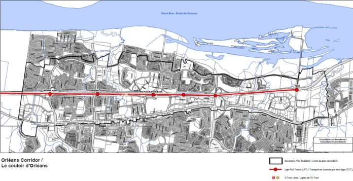
Ottawa’s planning committee has approved a new secondary plan for the Orléans rail corridor, which would guide growth on St. Joseph Boulevard and redevelop communities around Ottawa’s four easternmost LRT stations now under construction.
The Orléans Corridor Secondary Plan is one of the first local plans developed after the approval of Ottawa’s 2021 Official Plan. It focuses on creating 15-minute neighbourhoods by encouraging more housing and employment near transit and along the community’s main street. Guidelines promote mid-rise and high-rise redevelopment on underused properties along the rail corridor, which would lead to greater housing density with smaller and less expensive housing options.
“The vision of the Official Plan is for Ottawa to be the most liveable mid-sized city in North America,” the official plan states.
15-minute neighbourhoods are compact, well-connected places with a clustering of diverse mixed land uses, which includes a range of housing types and affordability, access to food, shops, services, schools, local childcare, employment, greenspaces, parks and pathways. The goal is to enable people to walk to meet their daily or weekly needs by brining destinations closer together. They enable easy, safe and enjoyable connections between destinations.
“The vision of this plan is for the Orléans corridor to evolve from a late 20th century auto-centric suburb into vibrant urban neighbourhoods centred around the O-Train stations and the St. Joseph Blvd mainstreet, where residents and visitors can walk, cycle or take transit to daily destinations,” staff wrote in the secondary plan introduction.
“New development in the corridor will bring a mix of land uses and amenities, including a variety of housing options, employment, and parks, built around a highly connected transportation network for all modes of travel, anchored by the O-Train.
Specific goals identified in the document include:
- Support the evolution of the Orléans Corridor into a community of 15-minute neighbourhoods that support health and well-being of residents:
- Direct the tallest buildings and densities to areas best serviced by rapid transit, walking and cycling, to create highly liveable mixed-use neighbourhoods
- Plan for additions and enhancements to the public realm, greenspaces, and promote climate resilience
- Prioritize and improve mobility for pedestrians and cyclists to support positive health outcomes and reduce greenhouse gas emissions
- Coordinate new built form with improvements to the public realm and mobility
Strategies also seek to attract more jobs, services and amenities to the area to create healthier, more walkable neighbourhoods. As part of any redevelopment, the plan outlines required contributions to the public realm as well. Developers would contribute to park space, and improvements to cycling facilities and sidewalks.
Council is expected to approve the secondary plan at its next meeting Sept. 21.


